Falling Out of the Tree

VRTool software support forum

Falling Out of the Tree

Postby mclean » Thu Dec 01, 2011 9:49 am

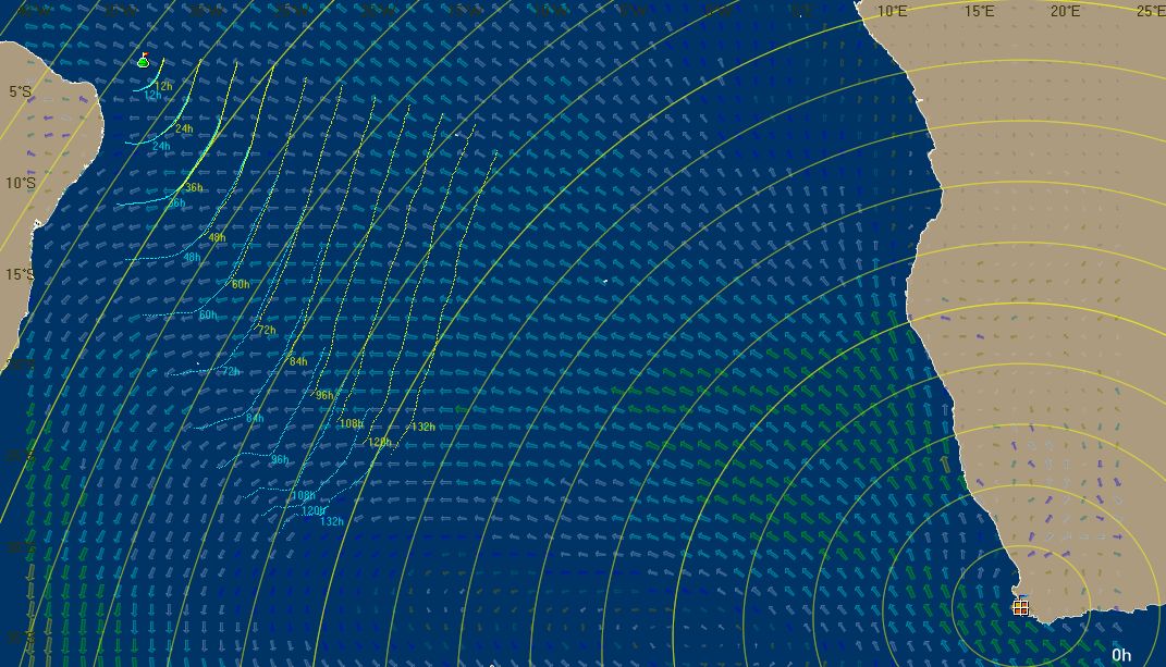
Hi Omar. In the VOR, for several days on the passage from Fernando de Noronha to Cape Town the correct optimum track was 70-80 degrees away from the direction to the destination. The biggest # of tree branches that will work seems to be about 20. If I understand it correctly, in reaching conditions this will test tracks up to 50 degrees away from the direction to the destination. So the routing selected the outermost track as the best one, sending boats 20-30 degrees to the east of the correct track (and towards the South Altantic high). The only way to see this error was to plot the isochrones, which showed the selected track going through the very ends of the isochrones.

I'm sure you've thought about this already, but is there any way to widen the tree on very long simulations? Maybe with more agressive pruning, or bigger time steps, or a bigger data array, or some other brilliant strategy. I know this would be less accurate, but at least there would be a good answer within the range of tracks tested.

That would make an excellent tool even better!
mclean
 
Posts: 36
Joined: Sun May 08, 2011 3:18 am

Weather Routing Blues

Postby omar » Thu Dec 01, 2011 12:08 pm

mclean wrote:..is there any way to widen the tree on very long simulations?

Yes. It seems there is always room for improvement in that WR calculation.
The current algorithm still stops and thinks at every "rectangle" border. With continuous
interpolated winds, this is a waste of time.

WR have so many parameters because of different boats and different world models.
I didn't find a set of filters that make sense for every possible condition.
You got to watch those parameters! You do it wrong and the calculation tree size
(i.e. the data structure used for simulating all possible tracks) goes over the roof.
The brute force calculation becomes too slow.

These are the WR params I'm using for VORG:
isochrone interval=0.5
Up to=132
Branches=19 (i.e. direct course+9 to each side)
max angle to destination=110
wake angle=35
show isochrones=12h
[x]Collision detection ( <- slows the calculation a bit. Use only when it makes sense)
[x]Auto prune (<--mandatory)
[x]Add branches at isochrones (<--- important for constantly changing winds)
(all options checked !! )

I'm using that with 144h winds downloaded directly from NOAA, w/ bilinear interpolation in position.
Two calculations are shown in the image below. Each took about 5 minutes.
Both start from Noronha. The yellow one goes to Cape Town directly.
The blue one goes to an intermediate <and strategic> southern location,
some 2000 NM, S-SE of Noronha. I did the second one to "widen the tree", as you say (a workaround, I admit :mrgreen: ).
The circles radiating from Cape town are spaced 200NM.

Image

still a work in progress...
User avatar
omar
Site Admin
 
Posts: 498
Joined: Thu Apr 30, 2009 11:00 am

Versão 1.98c pros bróde...

Postby omar » Tue Dec 06, 2011 8:26 pm

Mané.. olhaí: postei a versão 1.98c do vrtool

Arquivo http://www.tecepe.com.br/nav/vrtool/vrtool.zip
md5 E000DBF5352F3BD510904621C70D045B

alterações
- Roteamento - Opção para desabilitar a simulação por quadradinhos (p/ VORG)

- Importa ventos da NOAA até 384h
- Correções e otimizações no roteamento
- Rolou tb uma garibada no 3D (na iluminação)

Basicamente os parametros de roteamento ficam assim

VORG 11- iso=1 branches=29 max ang=100 wake=40 iso spacing=1% [x]Add branches at isochrones
VR- iso=1 branches=19 max ang=100 wake=40 iso spacing=1% [x]Add branches at full degrees

Bem mais relaxados.

Como sempre, unzipar o vrtool.exe por cima do anterior (em \program files\vrtool\)
Essa versão é uma daquelas com alto risco de bug do milenio... ;)

enjoy
Image
User avatar
omar
Site Admin
 
Posts: 498
Joined: Thu Apr 30, 2009 11:00 am


Return to VRTool Forum